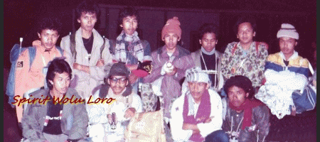
Spirit Wolu Loro
Geodet82-geodet82-geodet82-geodet82-geodet82-geodet82-geod
Tema Blog
Tema blog ini sekedar cerita kenangan belaka tentang rekan-rekan geodesi ugm angkatan 82 pada masa masa kuliah saat itu. Meskipun ada sedikit cerita tentang kegemaran, pengalaman bekerja dan informasi lainnya pada kondisi sekarang. Cerita dan informasi yang saya dapatkan antara lain dari membaca status dan melihat foto-foto serta informasi yang ada di dunia maya ( blog, tweeter, facebook). Sehingga Informasi tersebut bisa tidak benar atau kurang akuratnya saya dalam menyusun dan menyajikan dalam bentuk cerita dengan gambar atau foto, pada situasi dan kondisi nyatanya. Selain itu tema ini juga memberikan informasi tentang perkembangan kegeodesian pada akhir-akhir ini. Semuanya itu hanyalah untuk menjalin silaturahim diantara kita-kita rekan Jurusan T. Geodesi Fakultas Teknik ,Universitas Gadjah Mada angkatan 82 yang lama berpisah dan jarang bertemu satu sama lainnya. Tidak ada sama sekali niatan diri saya dalam menggoreskan pena berupa informasi dan cerita kenangan ini menyinggung atau menyakitkan pribadi rekan-rekan semua. Meskipun demikian saya juga manusia biasa yang penuh dengan sarat kesalahan, sehingga bila nantinya penyajian tulisan dalam cerita , ulasan kenangan dan informasi lainnya sekiranya tidak berkenan di hati rekan-rekan, saya mohon maaf serta mohon untuk ditegur dan dikoreksi terhadap diri saya. Akhirnya saya mengucapkan banyak terimakasih atas koreksi dan dukungan rekan-rekan dalam mewujudkan uneg-uneg dibenak saya. Terimakasih.......Salam kompak selalu .... Spirit geodet Angk. 82. .....Merdeka.
Reuni Angkatan 82

Geodet82-geodet82-geodet82-geodet82-geodet82-geodet82-geod
Kenangan Outsider 82
OutSider 82 dalam pendakian gunung Lawu.
Selasa, 11 Mei 2010. Maztanto 82
Riwayat terbentuknya OutSider 82 adalah sebuah kenangan tersendiri saat itu dengan adanya gap / kesenjangan diantara rekan2 seangkatan 82 yang tidak disadari oleh kita semua dalam ikatan emosional 82 . “ Out Sider “ yang dimaksudkan adalah orang-orang buangan di angkatan 82, yang merasa tidak di wongke / di ikutkan dalam kegiatan –kegiatan didalam angkatan itu sendiri. Saat itu terbentuklah panitia kecil yang ilegal tanpa ada keputusan tertulis Hitam di atas putih siapa ketua , siapa sekretaris, siapa anggota ..... tau – tau gosip / issu muncul dengan sendirinya lewat angin yang menghembus sampai telinga rekan-rekan sebagian angkatan . Dasar saat itu masih muda sifat emosinya dominan tanpa kendali .... dengan spontanitas membuat tulisan pada Spanduk berukuran berukuran 200 centi meter X 90 centi meter warna dasar hitam bertuliskan warna putih Out Sider 82 disertai pembuatan pembuatan kaos team warna hitam yang disablon tulisan out sider 82 seolah - olah seperti pejuang .Saking semangatnya saat itu sampai sampai melembur dalam pembuatan spanduk tersebut, dengan maksud akan dikibarkan di Puncak Gunung Lawu . Ha.....ha.....ha.. kwekkk...keekk....kekkk...kekkk...kekk dasar sial spanduk hilang tertinggal di kendaraan yang di tupanginya dalam perjalanan ke Tawangmangu. Itulah kenangan yang menjadikan kita semua geli , lucu, dan unik . Namun itu semua hanya bersifat temporer. Akhirnya kita semua menyadari bahwa perbedaan pendapat boleh saja dan jangan emosional dalam menanggapinya. Kembalilah saat itu kita dalam kekompakan Angkatan 82 Lagi. ........ (ee alah mas-mas mbasa dipikir- pikir kenangan-kenangan iku sing nggarahi ngangeni angkatan 82 ). He....he...he. salam kompak selalu.
Geodet82-geodet82-geodet82-geodet82-geodet82-geodet82-geod
Cergam

1. Geodesi Minded dalam foto membentuk Segitiga, lokasi di Deles Klaten
Geodesy Minded :
Geodesy Minded merupakan Agenda acara kegiatan rutin tiap tahun di Jurusan Geodesi Fakultas Teknik , Universitas Gadjah Mada. Acara ini diagendakan setiap awal bulan pada saat mahasiswa baru mulai memasuki kuliah. Geodesi Minded bertujuan untuk lebih mengenal apa itu geodesi dan bagaimana nantinya seorang yang berprovesi Surveyor? Dalam acara ini para calon2 surveyor atau geodet belajar seperti outound, mengenal medan yang terjal naik turun bukit ditempuh dengan lari kadang jalan kaki guna melatih fisik serta mental seseorang yang bakal jadi seorang Geodet. Kepercayaan diri , fisik yang kuat serta mental yang tangguh sangat diperlukan dalam profesi geodesi. Mengapa demikian...?Karena seorang geodet merupakan profesi yang pekerjaannya berkaitan dengan alam dalam mengambil data-data lapangan dalam wujud angka2 ukur. Karena bersinggungan langsung dengan alam, baik hutan, rawa, dalam cuaca panas ataupun hujan diperlukan fisik dan mental yang bagus. Pada saat istirahat selesai melaksanakan jalan dan lari naik turun bukit latihan fisik, rekan2 berfoto membentuk segitiga. Bila segitiga2 ini dirangkaikan dan saling mengikat satu sama lain dalam bentuk jaringan,hal ini menggambarkan Jaringan Trianggulasi. Ok begitulah semangatnya menjadi mahasiswa baru geodesi saat itu, apalagi nantinya jadi seorang geodet.
Minum kopi merupakan keinikmatan kita semua pada saat malam hari di lapangan. Bagaimana nggak nikmat, seharian sudah diplonco naik turun bukit-bukit, lari di sungai berpasir terus jalan jongkok , tiarap dan merayap di tanah yang telah diguyur dengan air yang diakhiri menerobos Statip sebagai pertanda syahnya sebagai anggota Keluarga Mahasiswa Teknik Geodesi Universitas Gadjah Mada. Dalam foto, masih terlihat riang gembiranya rekan2 meskipun dalam kecapaian. Kedinginan pada malam hari hal yang sering dihadapi oleh surveyor dan geodet dalam melaksanakan tugasnya. Mendirikan kemah yang bahkan mungkin flying camp bila nanti menghadapi survey pengukuran yang luas dan berlokasi di hutan belantara. Kopilah sebagai teman di malam hari sebagai obat ngantuk karena harus mengolah data yang diambil sebelumnya pada pagi sampai sore hari. Sruput....sruput....enak tenan. Itulah foto Mas Adi Isdiarto lagi ngopi.
3. Dalam Praktikum Pengamatan Bintang
Pengamatan Bintang, merupakan persyaratan yang harus dilakukan oleh siswa geodesi guna melengkapi nilai mata kuliah Ilmu antariksa (Astronomi). Di situ siswa2 geodesi harus bisa mempraktekkan bagaimana cara mendapatkan data bintang. Tentunya praktek pengamatan bintang dilakukan pada malam hari , lain halnya bila di pagi hari atau sore hari dilakukan untuk memperoleh data Azimut Matahari. Dalam Pengamatan Bintang tersebut, sangat-sangat berkesan mangapa? Kita semua menunggu bintang sampai didapatkan data, terkadang dalam cuaca yang sedikit mendung bintang tidak terlihat oleh karena tertutup awan. Disaat itulah yang mengasyikkan menunggu bintang tidak muncul2, gorengan beserta minuman kopi jahe ataupun ronde bermunculan. Ha..ha...ha...tamba ngantuk. Dalam foto tersebut berdiri Dasad Izani, Jefry Deson dan Budi Puwanto sedang njegegesan....menunggu bintang.
Geodet82-geodet82-geodet82-geodet82-geodet82-geodet82-geod
Wajah geodet Angkatan 82 Gama
Rekan-rekan geodet Angkatan 82 Gama
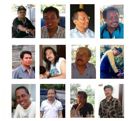
(1).Prihartanto, 2.Jefry Deson, 3.Muhtadi Ganda Sutrisno, 4.Triwibowo, 5.Hail Surisno, 6.Agus Budiyanto, 7.Rachmat Manumartono, 8.Bagus Pujiwahyono, 9.Djoko Trilaksono, 10.Sri Widodo, 11.Agung Wuryanto, 12. Zaenuri. Nama-nama tersebut untuk album foto yang berada di atasnya dari teks ini. Dari kiri ke kanan masih ingat to............?

(1). Marzuki Nur, 2. I Komang Wedana, 3. Sri Hardono, 4. Sakur Hamid, 5. Teguh Hartono, 6. Dwi Sigit Purnomo, 7. Indra Priatna, 8. Syaefuddin Ashari, 9. Frans Tri Dwi, 10. Hardi Sentosa, 11. Haryono, 12. Haryo Wijoseno. Nama-nama tersebut untuk album foto yang berada di atasnya dari teks ini. Dari kiri ke kanan masih ingat to............?

(1). Gatot Suritno, 2. Sujoko S, 3. Adi Darmawan, 4. Agus Widiyanto, 5. Ari Atmawan, 6. Agus Dwi Widiyanto, 7. Marsono Yulianto, 8. Imam Nugroho H.S., 9. Adi Isdiarto, 10. Basuki, 11. Budi Purwanto, 12. Dasad Irzani. Nama-nama tersebut untuk album foto yang berada di atasnya dari teks ini. Dari kiri ke kanan masih ingat to............?

(1). Ketut Giri Malaya, 2. Muhammad Besar Djoko Putranto, 3. Yudiar, 4. Setiawan, 5. Edy Meydarto, 6. Heru Asmoro, 7. Dwi Nowo Martono, 8. Sugeng Raharjo, 9. Syaefudin Ashari, 10. Prihartanto, 11. Teguh Hartono, 12. Mardjuki Nur.
Daftar Nama dan No. Telp. Geodet 82 Gama
DAFTAR NAMA-NAMA GEODET ANGKATAN 82 TEKNIK GEODESI FAKULATAS TEKNIK UNIVERSITAS GADJAH MADA
| NO | NAMA-NAMA GEODET ANKATAN 82 | KOTA ASAL | PEKERJAAN SEKARANG | DOMISILI SEKARANG | NO. PONSEL ATAU TELP |
| 1. | Adi Isdiarto | Salatiga | Swasta | Semarang | 081325623234 |
| 2. | Agung Wuryanto | Klaten | Swasta | Klaten | 08161959819 |
| 3. | Agus Dwiwidiyanto | Temanggung | Swasta | yogyakarta | 0811506886 |
| 4. | Agus Haryanto | Surabaya | | | |
| 5. | Agus M. Basuki | Kartosura | Swasta | Kartosuro | 085643207700 |
| 6. | Agus S. Budiyanto | Pacitan | Swasta/freeport | Surakarta | 081393353393 |
| 7. | Agus Widiyanto | Jakarta | Swasta | Jakarta | 081118388 9 |
| 8. | Ariatmawan Prihandono | Yogyakarta | Kimpraswil | yogyakarta | 081669327 2 |
| 9. | Bagus Puji Wahyono | Magelang | Janhidros | Jakarta | 081385338738 |
| 10. | Bambang Utoyo | Klaten | Swasta | Klaten | 08159693310 |
| 11. | Budi Purwanto | Muntilan | BPN Lampung | Bandung | 08882025867 |
| 12. | Dazad Irzani | Yogyakarta | Swasta | Cibubur | 0811887477 |
| 13. | Djoko Trilaksono | Madiun | Swasta | Jakarta | 02191600792 |
| 14. | Dwi Nowo Martono | Yogyakarta | Lapan | Jakarta | 08159949809 |
| 15. | Edy Meidarto | Lampung | Dosen | Lampung | 08127932861 |
| 16. | Frans Tri Dwi Budi R | Banyumas | Swasta | Semarang | 08881226160 |
| 17. | Gatot Suritno | Semarang | Swasta | Ungaran | 08157795528 |
| 18. | Hail Surisno | Palembang | BPN | Bandung | 08122235190 |
| 19. | Hardi Sentosa | Medan | Finance | Jakarta | 0861889175 |
| 20. | Haryanto | Pekalongan | swasta | Pekalongan | |
| 21. | Haryo Wijoseno | Blora | BPN Banyumas | Blora | 08156537586 |
| 22. | Haryono | Irian Jaya | Swasta | yogyakarta | 081578761917 |
| 23. | Heru Asmoro | Kendal | | | |
| 24. | I Komang Werdana | Tabanan | BPN Bali | Bali | 03617434663 |
| 25. | Imam Nugroho H. S. | Grobogan | Pertambangan | Kudus | 08122877518 |
| 26. | Indra Priatna | Jakarta | Pertamina | Jakarta | 0811816541 |
| 27. | Jefry Deson | | Chevron | Jakarta | 08121040194 |
| 28. | Ketut Giri Melaya | Singaraja | BPN Bali | Denpasar | 08155748108 |
| 29. | M. B. Djoko Putranto | Surakarta | Pertamina | Jakarta | 0811169730 |
| 30. | Marsono Julianto T. P | Yogyakarta | Bakosurtanal | Jakarta | 08131007632 |
| 31. | Marzuki Nur | Godean | BPN Wonogiri | Semarang | 08122968293 |
| 32. | Muh. Adi Darmawan | Yogyakarta | BPN Surabaya | Surabaya | 081367620284 |
| 33. | Muhtadi Ganda S. | Klaten | Bakosurtanal | Jakarta | 081295764 08 |
| 34. | Prihartanto | Ngawi | BPN Tegal | Tegal | 08164890128 |
| 35. | Rochmat Manu Martono | Klaten | BPN Majene | Semarang | 081325708030 |
| 36. | Saifudin Ashari | Magelang | Lurah | Magelang | 081575028535 |
| 37. | Sakur Hamid | Ambarawa | Lloyd | Depok | 081386826140 |
| 38. | Setiawan | Klaten | Swasta | Bogor | 085921654104 |
| 39. | Sri Hardono | Surakarta | Swasta | Karanganyar | 08122656141 |
| 40. | Sri Widodo | Yogyakarta | BPN Mojokert | Sidoharjo | 08123036559 |
| 41. | Sugeng Raharjo | Purworeja | Swasta | Magelang | 08157900191 |
| 42. | Sujoko Sungkono | Medan | Swasta | BandaAceh | 08126999352 |
| 43. | Sutoko | Kediri | | | |
| 44. | Teguh Hartono | Magelang | Swasta | Magelang | 08882749059 |
| 45. | Tri Wibowo | Tegal | BPN Kerinci | Brebes | 08179581110 |
| 46. | Winduno | Magelang | BPN Sulsel | Semarang | 0818247571 |
| 47. | Y. Dwi Sigit Purnomo | Yogyakarta | Bakosurtanal | Bogor | 08128477654 |
| 48. | Yudiar | yogyakarta | Swasta | yogyakarta | 081349774326 |
| 49. | Zaenuri | Bumiayu | BPN Banyumas | BumiAyu | 08156970197 |
Geodet82-geodet82-geodet82-geodet82-geodet82-geodet82-geod
Info geodesi
Informasi tentang Geodesi :
"Geodetic and Tidal Datum" dan " American Congress"
Geodet82-geodet82-geodet82-geodet82-geodet82-geodet82-geod
Introduction to Geodetic and Tidal Vertical Datums http://www.ngs.noaa.gov/corbin/class_description/Tid_Geo_Vert_Datums.shtml
American Congress on Surveying & Mapping http://www.acsm.net/index.cfm?fuseaction=Page.ViewPage&PageID=
Geodet82-geodet82-geodet82-geodet82-geodet82-geodet82-geod
Other Job Vacancies
Other Job Vacancies on Land Surveying And Geomatics OnLine Resources
Recent Job Posts: http://elowonganpekerjaan.com/search/Land+Surveying+and+Geomatics+OnLine+Resources
Geodet82-geodet82-geodet82-geodet82-geodet82-geodet82-geod et8
Welcome to the Land Survey
Welcome to the Land Survey Information System
The Land Survey Information System or LSIS is the official government Web site for the distribution of the Public Land Survey System (PLSS) of the United States. The Bureau of Land Management (BLM) cadastral survey program is responsible for the official boundary surveys for all federal agencies in the U.S. that together manage over 700 million acres. The Public Land Survey System also called the Rectangular Survey System is the foundation for many survey-based land information systems.
The PLSS data shown in the image to the right is computed from BLM survey records (official plats and field notes), local survey records, and geodetic control information. Please refer to the metadata for detailed information about the survey data. The LSIS data is a useful representation of the geometry and topology of parcels contained within the PLSS.
This data is intended for mapping purposes only and is not a substitute for a legal land survey.
PLSS Data
Check What's New for the latest updates.
What can I do on the LSIS site?
Download PLSS GIS shapefiles. To select and download data, select the Map Viewer and Download button. Once on the download site use the State Tab or County Tab (next to the words <<>) to select and download data for an entire state or county. To download just one or a few townships use the Township Selection Tool. Use the Quick Start Guide or Viewer Help on the download site for more information on getting started.
You must allow pop-ups to download data. Put www.geocommunicator.gov and www.blm.gov in the list of allowable sites.
For locating land descriptions by T/R or searching for land/mineral records use the Land & Mineral Use Records Link .
The PLSS data is also available as a map service for use in GIS applications. The map service allows you to stream the data live to your desktop GIS.
Map Server URL: http://www.geocommunicator.gov/
Map Service: BLM_MAP_PLSS
File Types
The Shapefiles are for use with GIS software such as ArcInfo, ArcView, ArcExplorer (download for free) or other GIS software. Shapefiles come with the following data:
- Townships
- Sections
- Subdivisions of Section
- Horizontal Control Information (Latitude and Longitude)
- Metadata
Original GCDB flat files are ASCII files that must be reformatted to be used with GIS software. The flat files are currently not available for downloading. If you need the flat files use the contact us to request them.
Data Sources
The PLSS data is coming from the National Integrated Land System (NILS). The current PLSS data are in NAD83 datum. The PLSS shapefiles available from LSIS before May of 2004 were in NAD27 datum.
In order to extend the national land grid to include the entire United States, PLSS data from alternate source data are added over time as the data becomes available. Alternate source data may overlap with BLM data. When this occurs, BLM data is the best source of information. Data from the U.S. Forest Service Automated Lands Project (ALP) is also being served. Data from non-BLM sources have not been verified and the BLM makes no judgment as to the quality and accuracy of the non-BLM data.
Not all of the U.S. has coverage at this time. This Web site is frequently being updated with the latest data available. Please review What's New for the latest information.
Contribute Data to LSIS
We are actively seeking additional survey-based data to fill in the areas we do not have coverage for. If you would like to become an "Alternate Source" provider of PLSS and Metes and Bounds survey-based data, select Contribute Data for more information. Metes and Bounds descriptions were a common method of survey in the eastern U.S. before the rectangular survey system was established. Metes and Bounds is a way of defining a parcel of land by describing the length of each course of a boundary and the monuments established at all the angle points.
GCDB ArcInfo coverages are available on request by clicking on the Contact Us link.
http://www.geocommunicator.gov/GeoComm/lsis_home/home/index.html
| GeoCommunicator is an official United States Government website provided by the Bureau of Land Management & the U.S. Forest Service. | |||
| | | ||
Geodet82-geodet82-geodet82-geodet82-geodet82-geodet82-geod et8
Bentley Cadastre V8i http://www.bentley.com/en-US/Products/Bentley+Cadastre/
Geodet82-geodet82-geodet82-geodet82-geodet82-geodet82-geod et8
Cadastre 2014 http://www.fig.net/cadastre2014/
| "Cadastre 2014" is the result of a working group of FIG-Commission 7 looking at trends and developments in the field of cadastre. The working group was active from 1994-1998 and presented the results at the FIG-Congress in Brighton in July, 1998. It projected the trends and developed visions of what cadastral systems might be in 20 years' time. Cadastre 2014 has received worldwide attention and has been translated into 27 languages. |
Geodet82-geodet82-geodet82-geodet82-geodet82-geodet82-geod et8
Cadastral Surveyor :
This site is privately supported reference providing information of interest to the land surveyor (also known as the Cadastral Surveyor) involved in the preservation and retracement of the Public Land Survey System (PLSS) in the United States. The term Cadastral, in the U.S., is most often associated with the Federal Land Surveying Authority. The PLSS is also known as the "rectangular system", and was a key factor in the orderly expansion west in the early history of the country. http://www.cadastral.com/
Geodet82-geodet82-geodet82-geodet82-geodet82-geodet82-geod et8
Cadastral Map: gambar Peta
A cadastral map is a map which provides detailed information about real property within a specific area. A simple example of a cadastral map might be a map of a village which shows the boundaries of all of the parcels or lots within the village, although cadastral maps can show other types of areas as well. These maps are usually maintained by the government, and they are a matter of public record; anyone who wishes to go to the office which maintains the records can ask to see them. http://www.wisegeek.com/what-is-a-cadastral-map.htm
Geodet82-geodet82-geodet82-geodet82-geodet82-geodet82-geod et8
Guides
Cadastral Maps
Definitions Cadastral
derives from the French cadastre and originally from the Greek Katastikhon and defines the extent, value and ownership of land for taxation purposes. http://www.nla.gov.au/map/cadastral.html
Geodet82-geodet82-geodet82-geodet82-geodet82-geodet82-geod et8
Generalization of cadastral map based on graphics matching
Abstract:
Old cadastral map records the geographic shapes of land partials and their related thematic information. It is generally drawn on an A3/A4 size paper and only presents the cadastral information of small city blocks. During the recent years, Japan government plans to make a kind of new cadastral map that is a typical formal map with the scale 1:2,500. So the editing works are needed to convert or transfer the old cadastral map to new one. The objective of this paper is to present the algorithms for automated generalization of old cadastral map based on graphics matching. Some practical examples are also given to show the efficiency of our algorithms.
Introduction
Old cadastral map records the geographic shapes of land partials and their related thematic information (such as land ID number, owner name, and prices). It is generally drawn on an A3/A4 size paper and only presents the cadastral information of small city blocks. During the recent years, Japan government plans to make a kind of new cadastral map that is a typical formal map with the scale 1:2,500. So the editing works are needed to convert or transfer the old cadastral map to new one. The purpose of this research is to develop the algorithms and a system for automated editing old cadastral map, which mainly contains feature point detection, feature point matching, conflicted line detection, automated conflicted line generalization. http://www.gisdevelopment.net/application/lis/rural/lisr0014.htm
Geodet82-geodet82-geodet82-geodet82-geodet82-geodet82-geod et8
Geodet82-geodet82-geodet82-geodet82-geodet82-geodet82-geod
Teknik Geodesi UGM Miliki Stasiun GPS Minggu, 28 Juni 2009 - 16:02 wib
Beita dari tecno.okezone.com/
http://techno.okezone.com/index.php/ReadStory/2009/06/28/56/233637/teknik-geodesi-ugm-miliki-stasiun-gps

UGM Memiliki Stasiun GPS
Stasiun GPS tersebut bisa menentukan posisi teliti objek yang dapat dipantau secara terus-menerus kemudian digunakan untuk kepentingan teknik dan rekayasa teknologi.
Peresmian GPS, Sabtu (27/6/2009) kemarin, dilakukan Menteri Pekerjaan Umum (PU) Djoko Kirmanto. Djoko mengatakan, GPS dapat difungsikan pada semua pekerjaan Departemen Pekerjaan Umum, dari pekerjaan yang sederhana hingga paling kompleks.
"Beberapa jenis pekerjaan PU yang memanfaatkan GPS adalah pada manajemen aset yaitu dengan GPS navigasi, sedangkan GPS tipe geodetik lebih sering digunakan dalam pekerjaan pemetaan dan monitoring," ujarnya.
Alat ini dikabarkan dapat mengoreksi data dengan tingkat ketelitian yang cukup tinggi, sampai orde milimeter, sehingga perubahan sekecil apa pun pada struktur bangunan dapat diketahui secara dini.
Ketua Jurusan Teknik Geodesi UGM Subaryono menambahkan, stasiun referensi GPS di atap gedung jurusan teknik geodesi tersebut juga dikenal sebagai continuously operated reference station (CORS) yang bekerja secara terus-menerus selama 24 jam.
"Stasiun yang dibangun atas kerja sama alumni dan jurusan tersebut akan mengeluarkan data koreksi terhadap kesalahan hasil hitungan koordinat yang terjadi akibat beberapa gangguan seperti penerimaan sinyal dari satelit GPS," katanya. Aplikasi CORS tersebut dapat digunakan untuk berbagai kepentingan seperti pemetaan tanah, navigasi pesawat terbang, serta deformasi bangunan besar seperti jembatan atau bendungan. (srn)
Refreshing
Info tentang geodesi di " The OHIO State University "
Info tentang “ The OHIO State University College of Engineering “:
http://www.ceegs.ohio-state.edu/GSGRADUATE/index.php
Civil & Environmental Engineering & Goedetic Science
Geodetic Science and Surveying Program
The Department of Civil and Environmental Engineering and Geodetic Science offers three areas of specialization within geodetic science at the graduate level - geodesy, photogrammetry, and mapping / geographic information science.. An enrollment of 60-70 graduate students in geodetic science allows small classes and an intimate learning environment.
Each student selects a program of study in consultation with an academic adviser. There are three recognized options available: Geodesy, Photogrametry, and Mapping and Geographical Information Science. Each of the options has a thesis track (plan A) and a nonthesis track (plan B). There is a common departmental core requirement of courses, and each option has its own specialized courses. In order to develop a broad perspective f geodetic science, a student in each option is required to take cross speciality courses in topics of the other options.
A student with the proper background usually needs five to six consecutive quarters to complete the M.S. requirements. Students returning to academic work after a long absence may need a longer time period. Because most courses are offered only once a year, it is important to start studies at the beginning of an Autumn Quarter, or to take some general catch-up courses (e.g., Math 254 or Math 568) in the preceding Summer Quarter. A working knowledge of computer programming in a high-level language is strongly advised, as well as a solid mathematical background, particularly in matrix algebra.
Course Requirements
For courses required for each of the three options see the options´ page below. Of these requirements, a maximum number of three graduate-level courses can be waived based on previous knowledge or experience. Waived courses cannot be used to reduce the Graduate School required minimum number of credit hours that students must complete.
- In Plan A, the Department also requires the completion of one course from Group I (Table 1)*. The minimum required elective courses for Plan B are also listed by specialization.
- Geodetic Science or Surveying courses at the 600 or 700 level may be substituted for Group II (Table 2)* courses with the approval of the student's adviser.
- The degree requirements may be modified to suit a particular student's need through a written petition approved by the Graduate Studies Committee.
- No course taken outside the Graduate School (e.g., continuing education) can be used for credit toward any graduate degree or toward the graduate grade point average.
- The Graduate School requirement to achieve a cumulative point-hour ratio of 3.0 or better for all graduate credit hours, in addition, will be applied to just those graduate-level courses listed in this document or approved by the Graduate Studies Committee.
Thesis (Plan A) Requirements
In addition to the completion of the course work, a student following Plan A must write a thesis under the supervision of his/her adviser. After the draft approval of the thesis, the student must pass the Master's Examination, which is related to the thesis topic but not necessarily confined to it. Generally this is an oral exam.
Non-Thesis (Plan B) Requirements
In addition to the completion of the course work, a student following Plan B must write a 3000-5000 word scientific paper and orally defend it satisfactorily prior to the Master's Examination. The Master's Examination for Plan B is a written, comprehensive examination covering material presented in the required courses.
Master's Degree via General Examination
A student may earn a Master's degree on the basis of satisfactorily completing the Candidacy Examination for Ph.D. under the following conditions:
- it is recommended by the student's adviser and the Graduate Studies Committee.
- the student does not already hold a Master's degree in the same field.
Graduate School Requirements
The student should consult the Graduate School Handbook for additional graduation requirements and procedures.
*See the specialization areas below for Tables 1 and 2. Specializations
Nggowes Sama2 Angk.82 Yoo

Nggowes .... yo
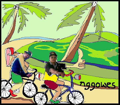
Klik Image .. Asyiiiik .... nggowes wisata


